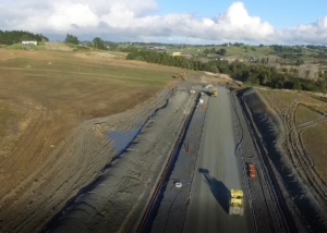
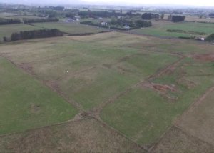
Previous design work carried out for this project resulted in an earthworks imbalance of 200,000m3 that the existing consultants were struggling to resolve. Candor3 were asked to review work to date and determine if a solution was available. The commercial component of the project was quickly resolved and a consent lodged to allow earthworks to [...]
Redhills Infrastructure Planning – Westgate
Planning and Urban Design
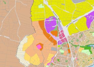
Watercare Services have engaged Candor3 to prepare an indicative scheme plan supported by 3d modelling for the Redhills area for the purpose of developing robust layouts for their trunk infrastructure. Candor3 have prepared an indicative scheme for approximately 10,000 dwellings that is consistent with the structure plan for the area but adds significantly more detail [...]
Hobsonville Workspace, Hobsonville
Commercial, Surveying
This is a small 14 unit commercial development. Candor³ have carried out the engineering design and observation works as well as dealing with all survey matters pertaining to the project. Similar Projects
333 Ormiston Rd, Flat Bush
Surveying
Purpose: Legalisation Survey This survey plan defined an area of legal road that had become redundant during the realignment of Ormiston Road. Sound advice, strong communication skills and comprehensive knowledge of the statutory road stopping process enabled our client to purchase this land from Auckland Transport. Our qualified surveyors added value to the project through [...]
79 Ormiston Rd, Flat Bush
Commercial, Surveying
A 15 hectare business park in East Tamaki. Candor³ have carried out all of the engineering design, management and survey for the project to date. Similar Projects
178 Point View Drive, East Tamaki Heights
Development, Residential, Surveying
Intersection Properties successfully had this property approved as an SHA after significant work to convince Council that with controlled landscape amenity a development could adequately deal with a visually sensitive ridgeline dominating the property. Initial schemes prepared as a part of the SHA process did not manage the steep contour well and Candor³'s first involvement [...]
130 Hobsonville Rd, Hobsonville
Residential
Candor³ carried out the engineering design and observation work for this integrated development in Hobsonville. Working with A Studio architects an efficient scheme was developed yielding 59 lots on the 2.0ha site. Similar Projects
248 Porchester Rd, Takanini
Surveying
Purpose: Post Development Settlement Monitoring The Resource Consent for this residential development requires our client to undertake a post development settlement monitoring programme for the five years following project completion. The stringent tolerances required of this monitoring requires careful selection of monitoring sites, collaboration with the client’s geotechnical representative and field surveying with utmost precision. [...]
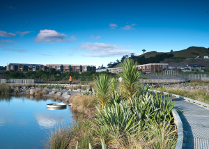
Stonefields Stormwater Treatment, Mount Wellington, Auckland
Water Resources
The Stonefields residential development lies within an old quarry basin with no option for gravity discharge of stormwater. Without proper consideration untreated stormwater runoff would put thousands of homes at risk of flooding and result in unsightly ponding and sedimentation at low points. Mark Sollner, while working for another consultancy, designed a system of rock [...]
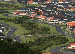
Catchment Management Plan, Flat Bush
Water Resources
The Integrated Catchment Management Plan (ICMP) for Flat Bush was prepared at a high level without an understanding of how individual land holdings would be developed. During detailed design of various land holdings it was identified by John Gardiner, while working for another consultancy, that significant cost savings could be achieved for land owners, Council and ultimately [...]
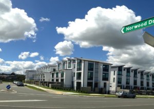
Norwood Drive, Flat Bush
Affordable Housing, Development, High Density, Residential, Surveying
A 29 lot integrated housing development in Flat Bush. Working on behalf of our client and in conjunction with Paul Brown Architects, Candor³ carried out the planning, surveying and engineering for this development. Working collaboratively with Council it was possible to arrive at an outcome that successfully met the needs of all stakeholders and sets [...]
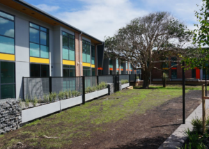
162 Flat Bush School Road, Flat Bush
Affordable Housing, Development, High Density, Residential, Surveying
Sited on a unique site with a significant stand of native bush spanning half the site this terraced house development is now consented and construction is due to commence in August. Significant thought has gone into this project and the finished result will display many unique features at prices that are some 25% lower than [...]
Northcote Shopping Centre
Surveying
Purpose: Topographic Survey Detailed, reliable topographic survey information forms the building blocks for all engineering and architectural projects. A topographic survey establishes what is onsite, where it’s located and quantifies it. Reliable topographic survey information is critical to establish design constraints for our Engineering Team and external architects to make informed design decisions. [...]
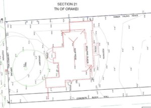
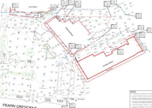
15 Tuhaere St, Orakei
Surveying
Purpose: Boundary Redefinition Knowing the exact extent of land ownership is critical to the redevelopment of any property. Our team of qualified surveyors search through historic land records and interpret them to calculate and demarcate property boundaries. We take the time to understand client objectives and work alongside them to achieve these with a collaborative, [...]
125 Murphys Rd, Flat Bush
Surveying
Purpose: Rural LT Subdivision & Removal of Title Limitations This five lot rural subdivision and removal of title limitations included an extensive investigation into historic land records dating back 100+ years, undertaking the survey of adjoining property occupation and defining a natural stream boundary. Successfully completing this subdivision facilitated land dealings and paved the way [...]
200 Hingaia Rd, Hingaia
Development, Residential
Comprising 76 residential sections including 8 affordable sections, this site lies on the shores of the upper Manukau Harbour in Karaka. The zoning of the land which was driven by Candor³ on behalf of the KARLA group of landowners was achieved through the SHA process. Similar Projects

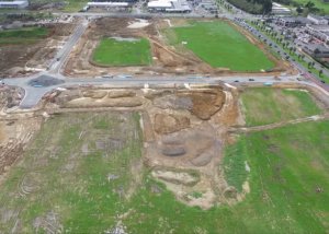
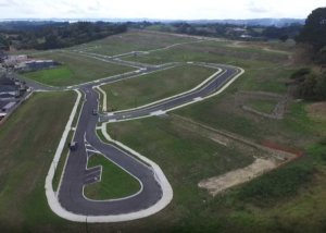
Formula E Racing
Social Events
We hit the track to test out the fastest indoor karts in NZ at Formula E Racing. Related Events
304 Linwood Rd, Kingseat
Development, Residential
A client came to Candor³ to have a due diligence carried out on this 12.0ha site. A scheme had been prepared for the land which gave a yield of 77 residential lots. After identifying various opportunities to increase density we reschemed the land and derived a 108 lot Council compliant development. Seeing the benefits of [...]
417 East Tamaki Rd, East Tamaki
Commercial
This small 27 unit commercial development in East Tamaki. Candor³ have carried out the engineering design and observation work as well as dealing with all survey matters pertaining to the project. Similar Projects
200 Flat Bush School Rd, Flat Bush
Development, Residential
Candor³ have carried out the engineering design and consenting works for this development in Flat Bush and will be continuing with the engineering observation, surveying and compliance works. The works involve the upgrade of a section of Flat Bush School Road from a two lane rural road to a four lane urban road with major [...]